The weather this day was the most unsuitable that could be ... heavy cloudy. Anywhere you looked at the sky, you could not find a hope of improvement. The kilometers was enough that we had planned to do, we did not know what would be the situation. Because of the bad weather, we decided to choose an alternative route-parallel to the initially planned-which, however, would save more than 100km. Furthermore, as depicted in the maps it seemed better.
We waited until 9:15 a.m., the owner of the apartment to come to pay and return the keys. We departed without wearing raincoats, with the hope that we would be able to pass beside the bad weather -once again-in our journey. Following, then, the signs-initially-to Dubrovnik, we left the beautiful Mostar and after a few kilometers we met the intersection Gasko - Nevesinje. We turned left and after a few kilometers we were next to the airport. An error reading the map, we thought that our road passed through the Blagaj. So we followed the signs to the particular village.
The Blagaj is, at least from what we could understand-an alternative place to stay near the tourist Mostar. It has enough accommodation and camping. The river passes through the village, it creates a stunning natural landscape, definitely worth a visit-and why not-and residence. At the time that we visited, it was almost deserted. When we realized our mistake, we returned back to the intersection, which was the airport and continued in an easterly course.
The road, though at the map is represented as a "national network", was relatively narrow and curvy. The quality was not bad, but because of that soon began to rain, it needed enough attention. The trail climbs 1000m altitude and the plateaus were more than 600-700m. The landscape had plenty of vegetation, which in some places reached to be too much thick.
Covering a few kilometers, we came across another sign advising that enters the region of Republika Srpska. Signs of such kind we met at various locations throughout the country. What you notice is that only in areas that live more Serbs you encounter these signs. In certain villages, the signs at the entry-exit were first written in Cyrillic and then in Latin, and in many cases the Latin name is erased. Almost in all the entrance you see the Serbian flag without the emblem in its center. In contrast, in areas that remain Muslims or Croats, things just happen instead. The plaques are the first in Latin and then in Cyrillic, and many of them are faded, Cyrillic names. Flags not often found in the country...
The route (100km) Mostar-Goska, consists a region road that belongs to the Serb region of the country. Tourism development was non-existent and only encountered two gas stations along it. In small villages-settlements, the most houses were damaged. In one moment, we had a little adventure which fortunately did not result in something serious. Mimis on a downhill bend, suddenly lost control of the motorcycle and was out of the road. For great luck, he did not suffer the slightest neither he nor the bike. We continued our journey, reaching Gasko.
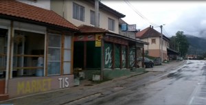
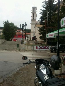
The first thing you see is the power plant. We headed downtown, where hosts an Orthodox church, cafes and a small bazaar. Having already traveled more than 100km., we felt it was a good opportunity to make a stop for coffee. We chose one of the two cafes that had special decoration internally and externally tinted windows ... We sat in the storefront and we watched the people and the village. We thought we were in the winter and we had changed country, reflecting on how our previous stop was in Mostar.
From Gasko and after, we march north. The weather was somehow ameliorated and it did not raining anymore. As we drove, we climbed altitudes, exceeding 1000m. After a few kilometers we met on our right the lake Klinje jezero, formed by the dam of a river. Shortly following, we were found in the village Cemerno, which essentially is the entry point to the National Park Sutjeska.
This is one of the most important national parks in Europe and has one of the oldest virgin forests, Perucica. Declared as "national park" in 1962 and has a rich fauna and flora. The age of many trees is more than 300 years and many species are endemic. It has a 75m waterfall. It is noteworthy that the initial hype of the park due to the fact that in this region, General Tito had won the Germans during the Second World War and not the specificity of the natural landscape..
From the very first kilometers we were impressed with the rich vegetation and the majesty of the mountains that rise above us. Essentially, we were moving into a canyon. An impetuous river kept us company along the way. Our weather showed some signs of improvement, which gave us the opportunity to enjoy the scenery more.
Just before the village Tjentiste, we found ourselves in a large plateau that was an abbandonded hotel and two large concrete monuments, the semantics of which they are unaware. Shortly following was some information points for the park, but-as expected-closed. We stopped to take pictures. In just a strong wind began to blow as a warning of what would follow ...we were prepared for "battle"!!!
We started and after a few kilometers it started raining... Clouds were covering the tops and in many cases we could not see, not even the mountains towards us. Nowhere was an opening in the sky, to give us some hope improvements... In this scene we continued our route, with serial-intensity reductions of rain ... We were trying, as it was possible to enjoy the journey, despite the adverse conditions!
With guide the signs to Beograd, we arrived in the town of Foca, in a landscape so beautiful - that - despite the rain we enjoyed with great pleasure!!! From that point on, the road was riparian along the river Drina. In the town Gorazde we met the junction to Visegrad and the ride became more impressive as successive tunnels and bridges were constructed in order to pass the road. The river view was impressive, but unfortunately we could not stop for more pictures due to the intense rain.
At 5pm we arrived in Visegrad, which-among other things-is known for its stone bridge features. It was build-initially-by Mehmet-Pasha Socolovic. Nowadays is undergoing restoration and maintenance. We stopped for coffee before we ride the last kilometers in Bosnia-Herzegovina, as the border abstained 20-25km. These last kilometers were impressive, leaving the best impression of a country that basically I did not know what to expect ... The truth is that I was positively surprised and I will definitely visit in the future...
A customs station was more reminiscent of police checkpoints despite the borders of two states... So we entered in Serbia and headed to the village Mokra Gora who abstained 5-6km. from the border. We had revisited in 2011 and then I promised myself that I would return soon, as we had not visited the village «Kustendorf» or «Drvengrad», or village Emir Kusturica.
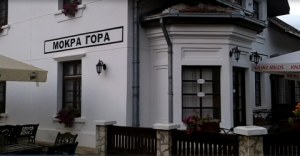
The plan this time was to stay there, but due to delay reservation ultimately we did not make it this time either. So, we chose the well-known places such as the hotel railway station Mokra Gora. The station is the starting point of a small train, made by a recreational trail and is associated with the film Kusturica, "The life is a miracle".
The train station has been converted into a hotel, and having a delicious and affordable food. We got lucky and found room (48€/4 persons). And we settled for lunch at the restaurant. We left our visit to Kustendorf for the next day in the morning before our departure for Nis, where we will wait for Achilleas, coming from Thessaloniki.


