On the occasion of the three-day of the Saint Spirit, but also the European elections, we decided to travel outside Athens. Without trying it much - because of our disposal for excursion we arranged to go in the coastal village of Loutsa (Preveza). It is a tourist resort in the prefecture of Thesprotia that it abstains hardly 40km. from Preveza. It mainly constitutes a known destination of many people of Epirus, for a few days escape from Giannena while it abstains hardly 120km.
The particular place was proposed from Giorgos and in its call, corresponded members of our travelling team so much from Athens, but also from Nafplio, Kalamata and Crete. At Saturday afternoon we were all there. This small meeting constituted the reason, we were found after enough time, with members except Athens. As it was expected we duly honoured the beach of Loutsa, but also the local cooker. The night closed with talk and teases and relaxation.
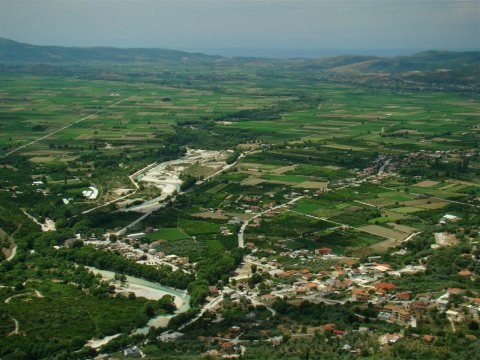
The next day (Sunday 6.6.2009), the sea did not accomplish to keep us without realising a small excursion in the wider region. One of the most basically sights is the Acherontas river. The unprecedented natural landscape that it offers in combination with the history that connects it with Ancient Greece, it also impresses the most exigent visitor!
We therefore decided to be directed in the village of Glyki, where are found the sources of Acherontas river. We followed the coastal street of Preveza - Igoumenitsa and in the node of Mesopotamos (or [Nekromanteio), we turned right with direction the village of Kanallaki (6km). In Mesopotamos is found the Nekromanteio, the history of that is connected immediately with the river Acherontas. It deserves the labour to visit it.
After we passed [Kanallaki], we followed the labelling for the sources of Acherontas river (13-15km). The village Glyki is built in the banks of the river. In parallel with the river exists asphalt roadway roughly 1.5-2km. that lead to a region with age-long plane (mainly in the left way of the river, in the node that you meet before you enter in the village). If someone follows the way that begins through the village, he will lead in the beginning of a path that begins riparian, it continues to the villages of Souli in order to lead to the “Gates of Ades”, near to the village of Trikastro.
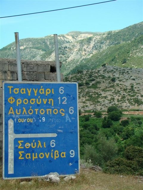
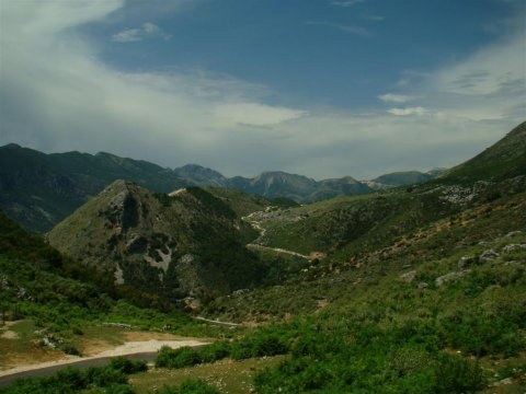
We made a few minutes stop and Giorgos Z. with Tassos took the street of return for Nafplio and Athens respectively, because of obligations. The remainders continued so that we visit the historical villages. Little afterwards the exit of village Gliki, is found the crossroad that leads to the wider region of Soulio. Following an uphill way 6km., we enjoyed an impressive view of the plain in the depth of which we could distinguish the Ionian Sea. Simultaneously we could distinguish the helical way of the river Acherontas, but also the mountainous volumes of Souli.
In the higher point is signalled the passage of the street between the sunken rocks. From there and beyond begins a comfortable downhill helical way that crosses a beautiful natural setting. After 4km., we met the node (a unique paved street that is without labelling) that it led in an old, devastated watermill (2km). For its existence it had informed us Michalis, the householder of the hotel where we resided in Loutsa. He had proposes us to visit it unconditionally and indeed it had right…
The old watermill was found in the banks of the river-stream Dala, which leads to Acherontas. Very tall plane trees supplemented the unprecedented setting. The most impressive however, was from the slot of a rock that came out impetuous water that passed side by side also in certain points through the watermill, creating small waterfalls! The written could not possibly be enough in order to attribute the particular beauty of the landscape. We did not lose the occasion to dive in the cool waters of a small baptistery that had been created…
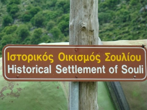
Definitely revived, we continued for the martyr village of Souli. After we returned in the central street (2km.) we led up to the crossroad for Souli (6km) - Samonida (9km). We reached in a beautiful and graphic way up to the settlement of Souli. As soon as we entered in the village we followed the street for Kougi that led to a small church. Little below was found the abrupt hill in the top of which is found the background small church. It exist a path via which you can approach. The lack of correct clothes and the excessive heat constituted suspensive factors to visit it. We enjoyed the landscape, while simultaneously we had the occasion to be informed for the history of the region but also the bureaucratic - and not only problems of the reconstruction of the settlement, from one local that happened to be there. Except the other, he informed us that each year is realised the representation of the siege and virtual explosion of the martyr small church.
We left Souli in order to visit the settlement Samonida (3km). It is famous for the castle of Kiafas that stands in the top of the rock, precisely above the settlement. You can visit it (30 minutes) via path. For the same reasons that we did not visit Koygi, we did not go up also at the castle. We rest in the shade of one enormous plane, before we took the street of return for Loutsa (65km).
Somehow thus, it finished the three-day excursion. Aris and Manolis continued for Giannena, while Nikolai, Sakis, Giorgos and Stergiani remained in Loutsa for one more day of rest and relaxation. I wish we will find again all together - and still more - soon…